Responding to increasing hydrological extremes: the case of Lodwar floods (PALM-TREEs)
/
Author: Meron Teferi Taye, International Water Management Institute (IWMI), Ethiopia
CLARE’s PALM-TREEs project held a workshop following the establishment of Turkana’s Climate Information System (CIS), the first of its kind being set up for a county in Kenya. The workshop was hosted by the International Water Management Institute (IWMI), one of the project partners of PALM-TREEs. During the workshop, which was held during May 21-23, the discussions focused on how to improve the new CIS system at this establishment stage.
IWMI, as part of the project PALM-TREEs is developing methods to forecast flood inundation areas through the use of machine learning and earth observation data. The lack of in situ data and information begs for finding other alternatives. The use of earth observation data and machine learning can be one avenue. A product that can be an input for the CIS. The adopted methodology focuses on training a regression model using rainfall from CHIRPS dataset and the month when that rainfall happened to predict areas of flood inundation. The inundated area is picked from remote sensing images expressed as normalized water index. This method is tested for Lodwar town and showed promising preliminary results.
Lodwar town is located at the downstream part of the Turkwel river basin, a river that flows from Mount Elgon on the border of Kenya and Uganda to Lake Turkana, the only freshwater lake in the arid lands of Kenya. Commonly the area is a dry land with no rainfall for the most part and high temperatures. Due to its location, the Lodwar town receives water from the surrounding hilly areas, both from inside and outside the country’s borders. Remote sensing images show the frequently flooded areas are locations close to the Turkwel river and at the confluence of River Kawalasee and Turkwel (Figure 1). During the workshop we have discussed with community members from the town who indicated similar locations as flood prone areas, verifying the applicability of the method. The community indicated that the Napetet village is where it commonly floods due to both flash floods and riverine floods. The River Kawalasee is mostly associated with flash floods while riverine floods are common overflowing the banks of Turkwel river.

Figure 1: Flood prone areas based on sentinel 2 images for the period 2016- 2023 (Image produced by Haileyesus Belay)
IWMI is also advocating the use of transdisciplinary research approach to produce well rounded understanding of the increasing extremes and contribute to creating transformative climate information tools by including stakeholders and communities. During the workshop we engaged with various stakeholders from government agencies, academia and local community member to map flood hot spots areas, grasp past flood hazards, impacts and responses. The year 2019 was highlighted as the worst flood period in recent years. More recent floods also occurred in April 2024.
Field visits to some of the flood hot spot areas showed that the worst-case floods that occurred in April 2019 can bring water to the town up to 2m above the ground, which is the highest flood mark we observed in houses. The community indicated floods commonly happen during the nighttime and water that comes with stones and other dribs causes severe damages.
According to the meteorological experts that participated in the workshop there are two types of rainfall amounts that translate to floods in the town. When it is normal rainfall the area outside the city center in the vicinity of 10 km can experience floods. When the rainfall is above normal (>2.5 mm/day), the town itself will be flooded, in worst case events all activities in the town were stopped, there were no roads that can be accessed by foot and people were using boats. The water accumulation can reach up to 1 m above the ground. This was the case for the 2019 floods.
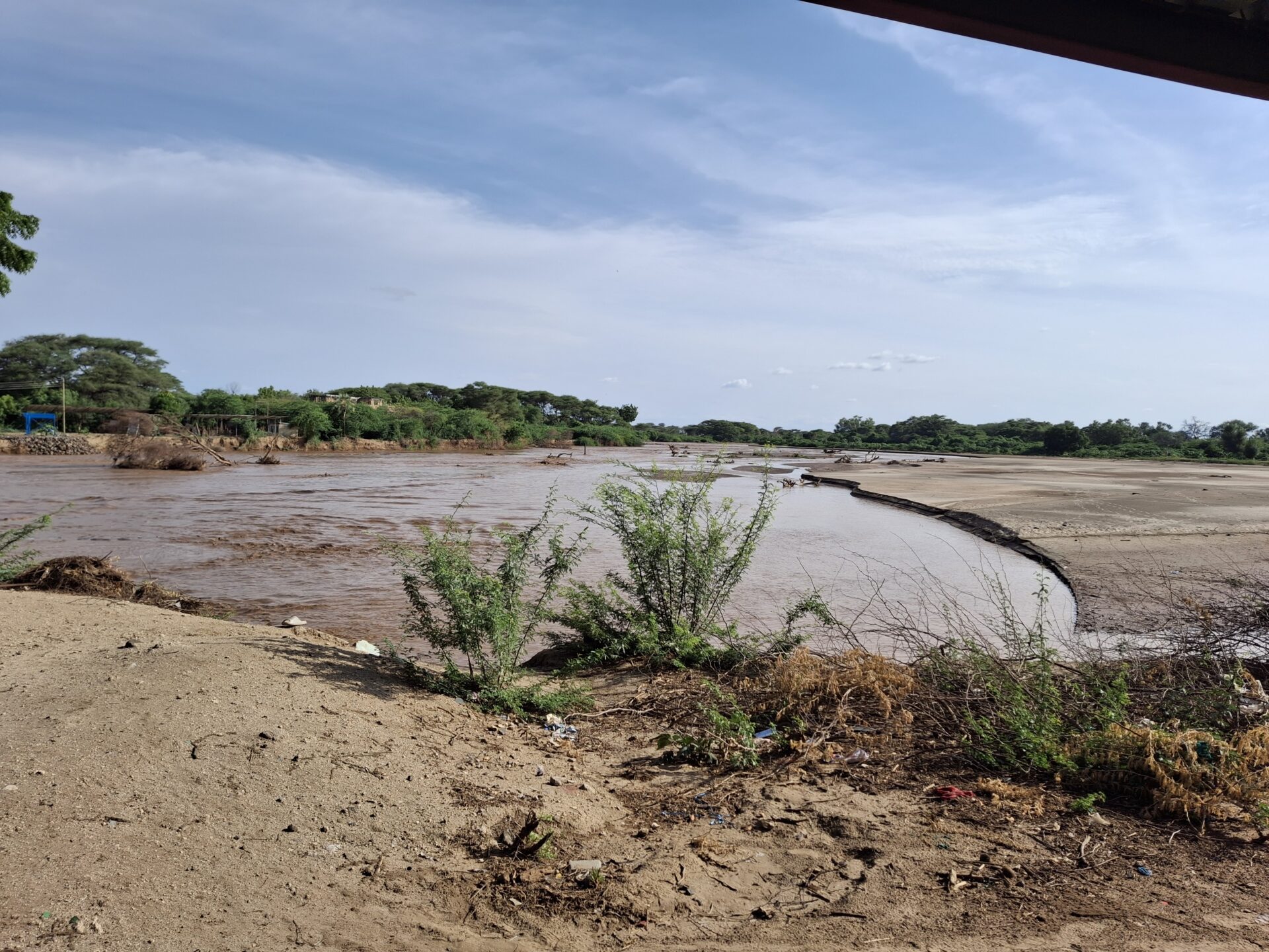
The impacts of flooding in this town can be devastating in several ways. Due to increased volume of water the river is changing its course as the riverbanks are being eroded (Figure 2). There is a borehole that is submerged due to the river expansion. Such damage to other boreholes in the area is highly likely if the frequency and magnitude of floods continue to increase.
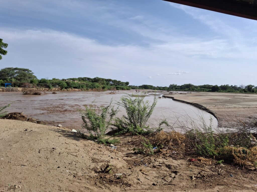
Figure 2: River Turkwel eroding and submerging the adjacent areas, pic taken 23 May 2025 (Photo credit: Meron Teferi Taye)
The Lodwar town sits on top of an aquifer that has potential to supply drinking water for the town. The location of some of these boreholes and a monitoring well recently established through support of REACH program are close to the river where riverbanks are being eroded. Some of the boreholes if they are maintained properly has the potential to serve the town for 3 decades to come. These boreholes are at the risk of damage or inundation due to floods. Losing the boreholes has multifaceted implication for the towns water supply and will impact vulnerable communities.
Engagement with various stakeholders and local communities provided the perspective on the multicausality of floods and the multi-dimensional impacts on the town’s society. The call to action for this town includes:
- Strengthening riverbanks to avoid erosion from floods. This requires substantial financial resources.
- Improving the poor drainage system of the town will minimize the effects of water stagnation when local rainfall is high.
- There are positive gains from high rainfall – the aquifer gets recharged, which then are used for the town’s water supply. Making sure this positive gain is not lost due to river changing course and submerging boreholes should be given priority.
- Leveraging traditional knowledge and combining with scientific forecasting could be explored for better outcomes.
Categories
Countries
CLARE Pillars
CLARE Themes
CLARE Topics
Published
CLARE Projects
CLARE Partners