
Story of Change: Strengthening and scaling community-based flood early warning systems in Durban, South Africa
Published on
Authored by University of KwaZulu-Natal (UKZN), ICLEI Africa, eThekwini Municipality
What changed?
Evidence from the INACCT Resilience project is informing how municipal forecast early warning systems (FEWS) are being operationalized and scaled across informal settlements in eThekwini Municipality, South Africa. Evidence and solutions advanced by residents of informal settlements, researchers and decision makers are enabling the Climate Change Branch, the Coastal Stormwater and Catchment Management Department, and the Disaster Management Centre to complement and replace desktop thresholds, which they had previously relied on for localized warnings, with community defined and scientifically tested threshold estimates developed in local contexts.
In riverine settlements, this has involved identifying vulnerable locations, understanding the river levels at which severe impacts are experienced by the community at specific landmarks (e.g. a house, goat pen or point along the river course) and then translating these into technical measures that can be integrated into the FEWS across a range of warning ‘levels’. These are communicated through the FEWS to the Municipality’s Disaster Management Centre to initiate response actions. In settlements not adjacent to rivers, thresholds were developed differently, for example identifying the particular combination of rainfall volume and duration associated with conditions likely to produce severe impacts if heavy rainfall continues (see Figure 3).
This represents an emerging shift in how the municipal FEWS is operationalized: moving from a system focused on modelled flood thresholds to the inclusion of more nuanced and context-specific community-determined thresholds which have been scientifically tested and that account for how impacts are experienced in specific locations. In this way, community-based observations and experiences are helping to improve the accuracy of flood alerts and the scale at which they can be applied, which are integrated into the heart of technical municipal forecasting systems. The innovation is therefore not the use of community thresholds alone, but the systematic combination of community knowledge with hydrological analysis, which produces reliable and locally specific thresholds that can be included in a city-wide FEWS system.
Why does it matter?
These changes are particularly important for informal and peri-urban settlements, where flood hazards intersect with exposure and vulnerability, including poverty; poor quality housing; inadequate services; lack of access to state resources, power, knowledge and influence; settlements developed without technical and planning oversight; and environmental degradation. Flooding can develop rapidly in these locations, causing severe loss of homes, land, livelihoods, and lives. This flood risk is increasing as climate change interacts with and exacerbates existing social and environmental vulnerabilities.
Integrating community-defined and scientifically verified thresholds into eThekwini’s FEWS makes the system’s warnings more accurate, reliable and trusted in the settlements where these thresholds have been established, and allows residents to develop clear plans for flood preparedness and response. More broadly, the work demonstrates a pathway for extending community-based early warning beyond one catchment, while retaining the local knowledge, relationships and scientific rigor that make the system effective.
What did CLARE do to contribute?
Since 2015, a community-based flood early warning system (CBFEWS) has been under development in the Palmiet Catchment in Durban South Africa, through a partnership between the eThekwini Municipality, local communities and the University of KwaZulu-Natal (UKZN). Since 2023, the INACCT project, led by ICLEI Africa in partnership with UKZN and eThekwini Municipality, has extended and strengthened its capabilities.
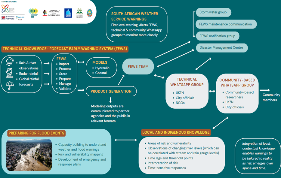
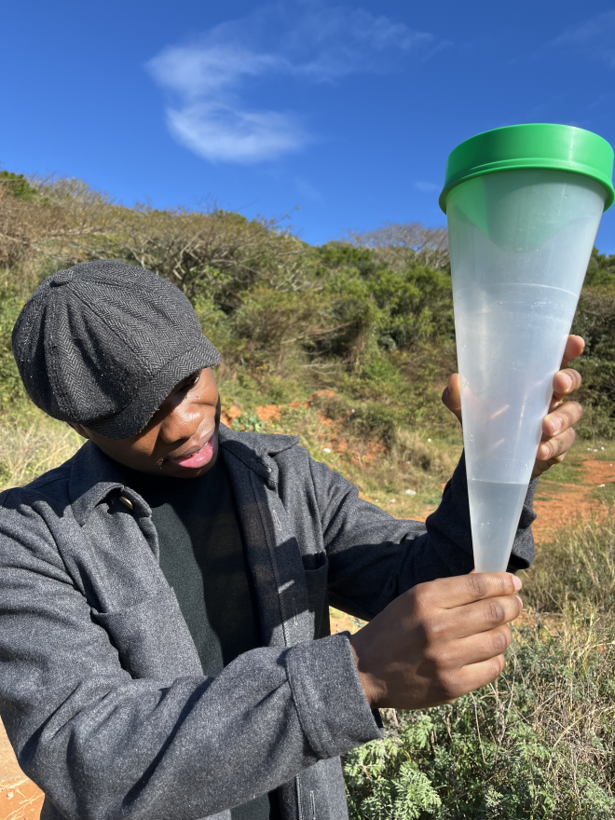
The CBFEWS relies on three main sources of knowledge: (i) a flood threshold developed through civic and specialist science, where rain gauge data from the middle catchment triggers warnings, once a threshold of 45 mm of rainfall during a rainfall event is reached, for community members of Quarry Road West, a highly exposed and vulnerable informal settlement on the Palmiet River floodplain; (ii) flood advisories from the municipal Forecast Early Warning System (FEWS) sent to a local technical WhatsApp group, which is then communicated by intermediaries, with contextual and scientific knowledge, to a community WhatsApp group to provide early warning advisories; and (iii) local knowledge and real time information exchanged between community members, researchers and municipal officials just prior to, during and after flood events (see Figure 1).
For over ten years, this community-based system has provided flood advisories in the Palmiet Catchment, particularly for Quarry Road West. However, the CBFEWS team and municipal officials in the Disaster Management Centre, identified important challenges: the system is people-intensive, operates in only one small catchment within the eThekwini Municipal Area, and relies on strong, trusted relationships between the state, citizens and researchers, developed over many years, which cannot be assumed elsewhere. These constraints raised several key questions for disaster risk reduction: whether, and how this system could be ‘replicated’, automated and scaled across Durban.
CLARE INACCT and CLARE Research for Impact (R4I) Opportunities Fund drew on evidence, solutions and lessons learned from the existing CBFEWS and piloted additional CBFEWS in three new settlements: Pholani, Umizinyathi and Tshelimnyama. This research advanced five interlinked changes. First, the existing CBFEWS was rigorously analysed and documented by the CBFEWS team to ensure a detailed understanding of how and why it worked, and where its weaknesses and gaps were (O’Donoghue, et al., 2025). This made the tacit knowledge embedded in a decade of practice more explicit and transferable, while broadening the CBFEWS to include evacuation practices and community level training (see Figure 2).
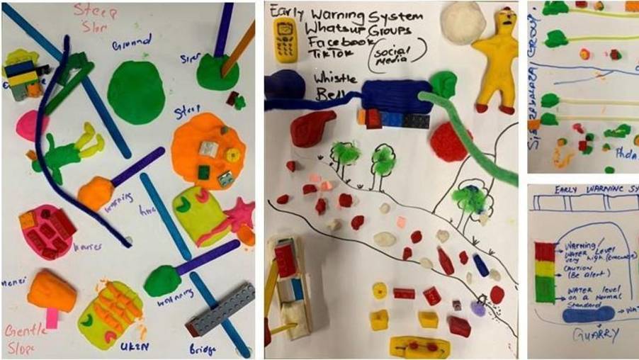
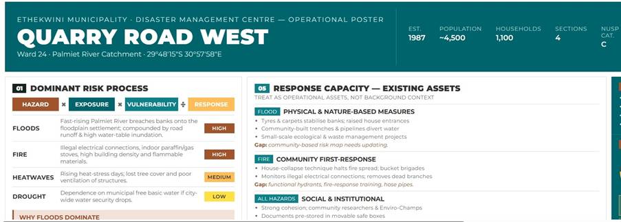
Second, the practices of the CBFEWS were adapted, transformed and further developed to support CBFEWS in three additional settlements, which included an informal settlement at risk to landslides, a peri-urban area at risk to pluvial and fluvial flooding, and a mixed land-use settlement, at risk to fluvial flooding. Here the context of each settlement, including its key stakeholders, its risk profile and climate action needs were identified using co-production methodologies and settlement profiles produced (see Figure 3).
Third, thresholds were developed for all three settlements using both specialist and civic science, which can be integrated into the FEWS system and used by local communities as a first level alert or advisory.
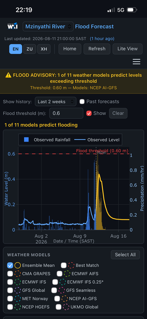
Fourth, an app was developed by Obscape, funded by the R4I Opportunities Fund, that provides advisories in the Palmiet and Mzinyathi catchments, using forecast modelling and correlations developed between rainfall and stream levels (see Figure 5). Community members have access to the app and can use it to monitor rainfall and stream level predictions, developed by global forecast models, as well as real time data on rainfall and stream levels.
The project team also supported institutionalization and knowledge sharing activities with eThekwini Municipality including the Disaster Management Centre and relevant catchment and stormwater functions.
About INACCT
The Designing Inclusive African Coastal Cities project (INACCT Resilience) works in coastal cities in Mozambique and South Africa to support municipalities and vulnerable communities in informal settlements and flood-prone areas to co-design gender-responsive and inclusive resilience approaches.
About the CLARE R4I Opportunities Fund
The CLARE R4I Opportunities Fund supports short-term, small-scale interventions that meet the needs of decision makers in Africa and Asia to adapt to climate change through the use of existing research and evidence.
Learn more:
- Early warning systems for disaster risk reduction in informal settlements: Durban’s CBFEWS
- Community based flood early warning system; Palmiet Catchment, Durban
- Barcena, A., Douwes, J., Karol, A., Leck, H., Priya, S., Raj, R., Schoonman, N., Sutherland, C. 2026. A Deleuzian approach to Urban Living Labs for transformative adaptation, Urbanisation, https://doi.org/10.1177/24557471261438
- Call To Earth Day | INACCT Resilience project – YouTube
- INACCT Resilience project CBFEWS uptake in Durban – YouTube
Categories
Countries
CLARE Projects
CLARE Pillars
CLARE Themes
CLARE Topics
CLARE Partners