Community-Led Embankment Management in Coastal Bangladesh: Local Strategies for Resilience and Disaster Preparedness a Study by SURF-IT
/
Md. Mustafizur Rahman, Nibraz Bahar, Gita Mistry, Md. Saddam Hossain, Delip Kumar, Hassan Abdullah Rafath, Zahid Amin Shashoto, Jahin Shams
ABSTRACT
This study, conducted in the Southwest Region of Bangladesh, focuses on assessing embankments, repair histories, and management strategies regarding tidal surges in villages of Koyra, Assasuni, and Shyamnagar Upazila in Khulna and Satkhira districts. It addresses community-led responses to breaches and overflows, outlining embankment dimensions, material compositions, and recommendations. Studies have highlighted that community-led embankment management is crucial in coastal resilience strategies, especially in Bangladesh, where extreme weather events frequently impact local infrastructure (Auerbach et al., 2015; Islam & van Amstel, 2018).
Methodologies included Focus Group Discussions (FGDs), Community Consultation, and the Community Participation Approach, aligning with participatory disaster risk reduction frameworks (Rahman & Rahman, 2020). The repair history highlighted major breaches and repairs carried out by various stakeholders over the years. Communities in Koyra, Assasuni, and Shyamnagar Upazilas mobilize swiftly to repair breached embankments using materials like mud, bamboo, and sandbags, coordinating with local authorities and prioritizing vulnerable groups. Similar approaches have been observed in disaster-prone regions where local knowledge and traditional techniques play an essential role in infrastructure management (Adger et al., 2013; Alam & Collins, 2010).
Recommendations included employing advanced technologies, dredging sedimentation, providing cash grants, and reinforcing embankments with concrete blocks and geo-bags. Research has suggested that reinforcing embankments with modern technology while integrating local adaptation measures can significantly enhance long-term resilience (Kabir et al., 2016). These findings contribute to proactive community engagement, resourcefulness, and resilience in managing embankments to mitigate flood risks in vulnerable areas of Bangladesh, aligning with the SURF-IT project’s objectives.
BACKGROUND
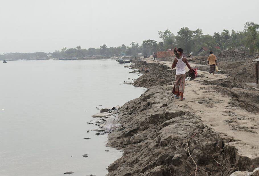
Southwest Bangladesh, characterized by its fertile delta plains and the Sundarbans mangrove forest, remains highly vulnerable to natural disasters. The region frequently experiences tidal surges and storm surges, which pose significant threats to local livelihoods and infrastructure (Huq et al., 2015). The rhythmic ebb and flow of tides occasionally escalate into treacherous tidal surges, causing abnormal increases in sea level, leading to widespread flooding and soil salinization (Dasgupta et al., 2014). Tidal surges exceeding 3 meters have been recorded in the Bay of Bengal, with approximately 20% of Bangladesh’s landmass prone to tidal flooding (IPCC, 2022).
The Sundarbans, with their dense mangrove roots, serve as a natural buffer against these surges, mitigating their impact and safeguarding inland communities (Rahman et al., 2019). However, deforestation and climate change are gradually weakening this vital defense system, heightening the vulnerability of coastal communities (Alongi, 2015). Studies have shown that mangrove restoration and conservation are crucial to embankment protection and flood mitigation (Ghosh et al., 2015).
Bangladesh faces an average of five cyclones annually, with at least one or two making landfall, bringing devastating storm surges (MoEFCC, 2018). Cyclone Bhola in 1970, for instance, claimed over 300,000 lives, while recent cyclones such as Sidr (2007) and Aila (2009) caused widespread destruction, leading to significant embankment failures (Paul, 2009). The destruction caused by these events underscores the urgent need for robust mitigation strategies and international cooperation to protect coastal regions (Ahmed et al., 2016).
The Satkhira region is particularly susceptible to climate change and natural disasters due to its geographical and socio-economic characteristics (Islam et al., 2014). Traditional top-down approaches to embankment management have often failed due to inadequate community engagement (Roy et al., 2017). Therefore, locally led solutions are essential in managing embankments to withstand the frequent threats of cyclones, tidal surges, and flooding. The Community Consultation for Identifying Local-Led Solutions for Embankment Management initiative aims to empower local communities to develop sustainable embankment management strategies using indigenous knowledge, fostering resilience and disaster preparedness (Chowdhury et al., 2021). By involving communities in embankment management, the initiative seeks practical, locally adapted solutions that enhance resilience, foster social cohesion, and ensure sustainable outcomes amid climate change and natural disasters.
OBJECTIVES
- To find out the weak point of the embankment in the selected area.
- To understand the embankment management strategy and the community-driven solutions.
- To understand the role of community participation and collective action in embankment management.
METHOD & STUDY AREA
Study Design
This study follows a qualitative research approach and employs Focus Group Discussions (FGDs) as the primary data collection method to achieve the research objectives.
Sampling Method
Purposive sampling was used to ensure diverse perspectives, with 30 FGDs conducted across six unions in three upazilas (sub-districts). Each FGD included 10 participants, totaling 300 participants.
Data Collection
A semi-structured guide was used to lead the discussions, and all sessions were audio-recorded to ensure accuracy. Ethical considerations were paramount, with measures taken to maintain participant anonymity, obtain informed consent, and provide a safe environment for discussions.
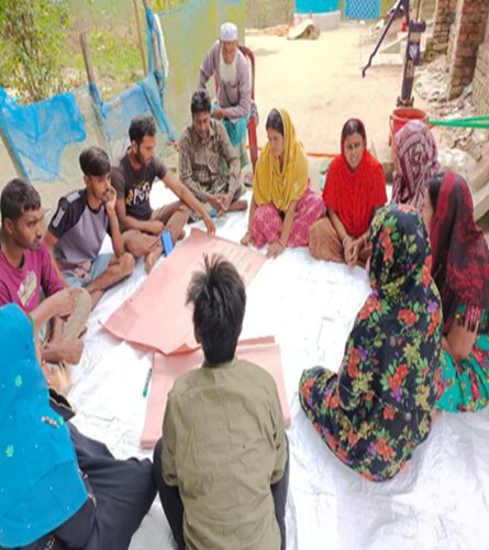
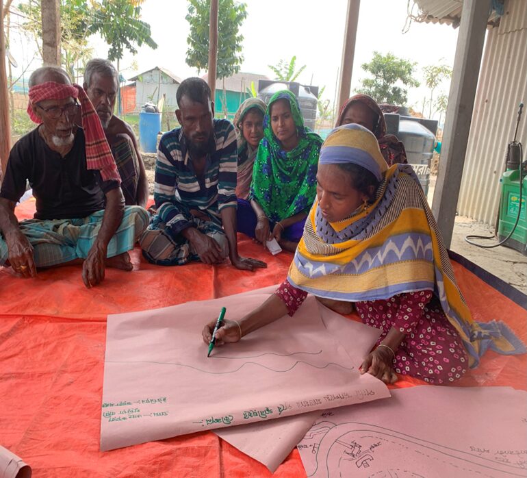
Community Consultation
For the community consultation, 10 participants were selected from each village, ensuring diversity in gender, disabilities, and representation of vulnerable groups. The villages were chosen based on their proximity to embankments within the study area. During the consultation, participants identified weak points of the embankment by drawing on brown paper and shared their local-led solutions for embankment management, along with recommendations for improvement. Following the consultation, participants signed an attendance sheet to confirm their presence and received snacks as a token of appreciation.
Study Area
The study was conducted in three upazilas: Shymnagar, Koyra and Assasuni. These regions were selected due to their high vulnerability to tidal surges and cyclones.
Ethical Considerations
- Anonymity: Participant anonymity was maintained throughout the study.
- Informed Consent: Informed consent was obtained from all participants.
- Safe Environment: A safe and respectful discussion environment was ensured.
Data Analysis
The audio recordings from the FGDs were transcribed verbatim and analyzed thematically. Thematic analysis was used to identify key themes and patterns in the data, providing insights into community perspectives and solutions for embankment management.
FINDINGS
Description of the Existing Embankment
Table-1 describes the general information of the existing embankment. The majority of the embankments range between 10-12 meters, and the highest range is 14-20 feet.
| Upazila | Union | Village | Embankment Dimensions (Width to height) | Construction Materials | Date of Construction |
| Koyra | Uttor Bedkashi | Gazipara | 12 to 10 feet | Mud, Concrete bags, geo bags | After 1971 |
| Gabbunia | 10 to 8 feet | Mud, sand, Concrete bags, geo bags | After 1971 | ||
| Hajotkhali | 12 to 11feet | Mud, sand, geo bags | 1965 | ||
| Pathorkhali | 8 to 10 feet | geo bags, block, mud, bricks | After 1975 | ||
| Ratnagheri | 8 to 12 feet | Mud,geo bags | After 1971 | ||
| Koyra Sadar | Harinkhola | 14 to 16 feet | Mud, geo bags | After 1971 | |
| Gobra Purbochok | 15 to 16 feet | Mud, sand,geo bag , geo tube | After 1971 | ||
| Guriabari | 7 to 12 feet | Mud, sand, geo bags | 1980 | ||
| Ghatakhali | 10 to 12 feet | Mud, sand, Concrete block | After 1971 | ||
| Gobra | 15 to 16 feet | Mud, sand, geo bags | After 1971 | ||
| Assasuni | Assasuni Sadar | Doyarghat | 20 to 14 feet | soil, concrete-blocks and geo bags | After 1971 |
| Jelekhali | 10 to 14 feet | Soil, sand, bamboo, geo-bags, tent Fabric, sand bags. | Within 1962-1963 | ||
| Manikkhali | 2 to 6 feet | Soil, bamboo, geo-bags | After 1971 | ||
| Thakurabad | 10 to 14 feet | mud, sacks, sand, tent fabrics, bamboo, tree branches | After 1971 | ||
| Bolabaria | 17 to 8 feet | Mud | About 100 years ago | ||
| Sreeula | Uttar Puijala | 15 to 12 feet | mud, sacks, geo-bags, concrete blocks, pitch, bricks | 1962 | |
| Dakshin Puijala | 14 to 12 feet | Mud, bamboo, sacks, tent fabric, sand | After 1971 | ||
| Thanaghata | 20 to 25 feet | Mud, sand, bamboo, concrete blocks, sacks | 1965 | ||
| Hazrakhali | 20 to 25 feet | Mud, sand, bamboo, concrete blocks, sacks | After 1971 | ||
| Mariala | 18 to 18 feet | Geo-bags, sand, bamboo, mahogony tree logs, mud, grass, concrete blocks | About 100 years ago | ||
| Shaymnagar | Ramjan Nagar | Vetkhali | 18-20 feet to 6-7 feet | Sand, mud, concrete | 1983 |
| Tengrakhali | 12 -15 feet to 7-10 feet | Mud, sand | After 1971 | ||
| Tarinipur | 7 -10 feet to 4-5 feet | Mud | Before 1971 | ||
| Sora | 7-10 to 3-5 feet | Mud | After 1988 | ||
| Kalinchi | 5-14 to 8-10 feet | Compacted Soil | Within 1970-1978 | ||
| Koikhali | Koikhali | 8-15 feet to 3-5 feet | Soil, geo-bags,concrete blocks | Before 1971 | |
| Poranpur | 10-15 feet to 8-15 feet | Soil, geo-bags, concrete blocks | 1966 | ||
| Nidoya | 4-10 feet to 5-7 feet | Compacted soil, geo-bags,concrete blocks | 1964 | ||
| Mirjapur | 5-6 feet to 6-7 feet | Compacted soil | 1964 | ||
| Boishkhali | 8-14 feet to 6-10 feet | Compacted soil | 1985 |
Description of the Embankment Breach & Repair Mechanism
Table-2 describes the general information of the embankment breach and repair mechanism
| Village | Breach Occurrence | Breach Repairing time | Repairing Material |
| Gazipara | 2009, 2010, 2020 | 2009, 2010, 2021 | Mud, bamboo kanchi, goler chal, branches of trees |
| Gabbunia | 1988, 2009, 2020, 2021 | 2010, 2021 | Geo bag, sand, mud |
| Hajotkhali | 1988, 2007, 2009, 2020 | 2012, 2020 | Geo bag, sand, mud |
| Pathorkhali | 1988, 1996, 2009, 2020 | 2009,2021 | Geo bag, sand, mud |
| Ratnagheri | 1988, 2007, 2009, 2020 | 2012, 2020 | Geo bag, sand, mud |
| Harinkhola | 1988, 1996, 2009, 2020 | 1988, 1996, 2009, 2020 | Geo bag, sand, mud |
| Gobra Purbochok | 1988, 2007, 2009, 2016, 2020, 2021 | 1988, 2007, 2009, 2016, 2020, 2021 | Geo bag, sand, geo-tube, mud |
| Guriabari | 1988, 2007, 2009, 2020 | 1988, 2007, 2009, 2020 | Geo bag, sand, mud |
| Ghatakhali | 1988, 2007, 2009, 2020, 2021 | 1988, 2007, 2009, 2020, 2021 | Geo bag, sand, mud |
| Gobra | 1988, 2007, 2009, 2016, 2020, 2021 | 1988, 2007, 2009, 2016, 2020, 2021 | Geo bag, sand, mud |
| Doyarghat | 1995, 2009, 2020 and 2021. | 1995, 2009, 2020, 2021, 2024 | Bamboo, bags, tree branches, soil |
| Jelekhali | 1995, 2009, 2020 and 2021 | 1989, 1997, 2010-2011, 2021, and 2022 | Soil, Sand, Bamboo, Geo-bags |
| Manikkhali | 1988, 2007, and 2009 | 1988, 2007, and 2009 | Soil, bamboo, geo bags |
| Thakurabad | Every year from 1996 to 2022. | Every year from 1996 to 2022. | Mud, sacks, sand, tent fabrics |
| Bolabaria | 1995, 2019, 2020, and 2021 | 1998, 2009, 2019, 2020, 2021, and 2023 | Mud |
| Uttar Puijala | 2009, 2018, and 2022 | 2009, 2018, and 2022 | Mud, sacks, geo-bags, concrete blocks |
| Dakshin Puijala | 2006 and 2009 | 2006, 2009 and 2023 | Mud, bamboo, sacks |
| Thanaghata | 1988, 2005, and 2018 | 1988, 2005, 2018, 2021 | Mud, sand, bamboo, concrete blocks |
| Hazrakhali | 1988, 2009, 2016, 2020, and 2021 | 1988, 2009, 2016, 2020, and 2021 | Mud, sand, bamboo, concrete blocks |
| Mariala | 2017 and 2020 | 2017, 2020 and 2024 | geo-bags, sand, bamboo |
| Vetkhali | 2007 and 2009 | 2017 | Sand, mud, asphalt |
| Tengrakhali | 2009, 2020, and 2021 | 2023 | Mud, Sand |
| Tarinipur | 2009 | 2009 | Mud |
| Sora | 1988,2009 | 1988,2009 | Mud |
| Kalinchi | 2007, 2009, 2019, 2020, and 2021 | 2009 | Compacted Soil |
| Purba Koikhali | 2007, 2009, 2019, 2020, and 2021 | 2009,2023 | Compacted soil, Geo-bags and concrete blocks |
| Poranpur | 2007, 2009, 2019, 2020, and 2021 | Ongoing | Compacted soil, Geo-bags |
| Nidoya | 2007, 2009, 2019, 2020, and 2021 | 2024 | Compacted soil, Geo-bags and concrete blocks |
| Mirjapur | 2007, 2009, 2019, 2020, and 2021. | 2020,2023 | Compacted Soil |
| Boishkhali | 2007, 2009, 2019, 2020, and 2021 | 2009,2023 | Compacted Soil |
Immediate Community Responses to Embankment Breaches
When the embankment breached, men and women joined forces in Koyra Upazila to quickly initiate repairs. They utilized materials such as mud, bamboo, tin, sacks (bosta), tree branches, and other items. This collaborative effort also involved using rope, nails, leaves of the golpata tree, and baskets to effectively address the situation.
In Assasuni Upazila, when embankments are breached, the community springs into action with urgency. They collect vital materials like mud, bamboo, sacks, tree branches, and tools to mend the breach, reinforcing it with bamboo stakes and sandbags. Makeshift barriers such as mud-filled boats and bamboo cages are employed. Coordinated efforts with local authorities include forming human chains to prevent overflow, while awaiting guidance. This proactive approach includes widespread community alerts, strategic resource allocation, and a unified effort to safeguard against ongoing damage and flooding.
After the breach in Shyamnagar, vulnerable groups such as children and the elderly sought safety in cyclone shelters. Quickly, both men and women joined forces to repair the damage using mud, bamboo, tin, sandbags, rope, nails, Golpata tree leaves, and branches. Their collaborative efforts aimed to secure the affected zones and protect those most at risk, demonstrating the community’s resilience and preparedness in confronting natural disasters.
Community Strategies for Embankment Management
- Identify vulnerable sections of the embankment.
- Alert the community about potential risks.
- Collect plastic sacks (bosta) and baskets (jhuri) from every household.
- Reinforce the embankment by piling it with tree branches and bamboo.
- Increase embankment height using mud and sandbags, often filled in plastic sacks.
- Strengthen the embankment with bamboo fences and tin.
- Mobilize local funds to purchase bamboo, nails, and other materials for strategic reinforcement.
- Use mud and sandbags to fill breaches and raise embankment levels.
- Monitor the embankment regularly for cracks and potential breaches.
- Coordinate through mosque announcements and community alerts during emergencies.
RECOMMENDATIONS
- Construct a sustainable embankment with a minimum height of 15 feet and width of 12 feet.
- Increase the embankment height and build an asphalt road on top.
- Use concrete blocks and bamboo bundles at vulnerable points to strengthen the embankment.
- Plant trees in the wetland area and along the embankment to prevent erosion.
- Cease deforestation and illegal river land occupancy.
- Discontinue the use of pipes under the embankment to prevent weakening.
- Regularly repair and maintain the embankment.
- Stop farming saltwater Gher; introduce paddy cultivation.
- Construct new sluice gates to control water flow.
- Widen the embankment base to 100 feet to reduce river current impact.
- Use geo-bags, geo-tubes, and mud to fill and strengthen the embankment.
- Introduce advanced technologies and dredge river sedimentation.
- Restrict heavy-weight vehicles on the embankment road.
- Provide materials (baskets, sacks, nails, etc.) and cash grants for disaster preparedness.
- Raise public awareness and form a local committee to identify and address weak points on the embankment.
The recommendations put forth by the communities encompass a range of measures to enhance embankment resilience, including the construction of a sustainable 15-foot-high embankment with an asphalt road, the use of concrete blocks and bamboo bundles for reinforcement, tree planting to prevent erosion and the installation of new sluice gates for water flow control. Additionally, the communities advocate for the cessation of deforestation and saltwater gher farming, promoting instead paddy cultivation and advanced technological interventions like dredging sedimentation.
CONCLUSION
This study provides a comprehensive assessment of embankment conditions, repair histories and management strategies in response to tidal surges in the Southwest Region of Bangladesh, focusing on the villages in Koyra, Assasuni and Shyamnagar Upazilas. By employing methodologies such as Focus Group Discussions (FGDs), community consultation and the community participation approach, the research underscores the pivotal role of community-led initiatives in embankment management.
The findings reveal that communities in these regions demonstrate remarkable resilience and resourcefulness in managing embankment breaches. Local residents quickly mobilize to repair breaches using readily available materials like mud, bamboo and sandbags, coordinating efforts with local authorities and prioritizing the needs of vulnerable groups. Regular monitoring and proactive disaster management practices, including community alerts and reinforcement activities, highlight the communities’ preparedness and ability to respond to emergencies.
The study’s conclusions emphasize the importance of integrating community knowledge and participation into broader disaster management frameworks. The proactive engagement, resourcefulness and resilience demonstrated by these communities provide valuable insights for policymakers and stakeholders involved in tidal surge risk mitigation in vulnerable regions. Aligning with the SURF-IT project’s objectives, the research contributes to the development of sustainable and locally-informed embankment management strategies, ensuring better preparedness and resilience against future tidal surges and cyclones in Bangladesh.
REFERENCES
Adger, W. N., Arnell, N. W., & Tompkins, E. L. (2013). Successful adaptation to climate change across scales. Global Environmental Change, 15(2), 77-86. https://doi.org/10.1016/j.gloenvcha.2013.02.002
Ahmed, B., Rahman, S. H., & Islam, D. (2016). Cyclone resilience and adaptation strategies in coastal Bangladesh. Natural Hazards, 81(1), 173-194. https://doi.org/10.1007/s11069-016-2095-1
Alam, E., & Collins, A. E. (2010). Cyclone disaster vulnerability and response experiences in coastal Bangladesh. Disasters, 34(4), 931-954. https://doi.org/10.1111/j.1467-7717.2010.01178.x
Alongi, D. M. (2015). The impact of climate change on mangrove forests. Current Climate Change Reports, 1(1), 30-39. https://doi.org/10.1007/s40641-015-0002-x
Auerbach, L. W., Goodbred, S. L., Mondal, D. R., Wilson, C. A., Ahmed, K. R., & Roy, K. (2015). Flood risk of embankment failure in the Bengal delta. Nature Climate Change, 5(2), 153-157. https://doi.org/10.1038/nclimate2472
Chowdhury, M. R., Haque, C. E., & Driedger, S. M. (2021). Community-based disaster risk reduction in Bangladesh. International Journal of Disaster Risk Science, 12(3), 312-329. https://doi.org/10.1007/s13753-021-00330-4
Dasgupta, S., Hossain, M. M., Huq, M., & Wheeler, D. (2014). Climate change, soil salinity, and the future of coastal Bangladesh. World Bank Policy Research Working Paper. https://doi.org/10.1596/1813-9450-7146
Ghosh, T., Das, M., & Hazra, S. (2015). Mangrove afforestation: Enhancing coastal resilience under climate change. Ocean & Coastal Management, 118, 42-52. https://doi.org/10.1016/j.ocecoaman.2015.09.012
Huq, S., Rahman, A., & Konate, M. (2015). Vulnerability and adaptation to climate change in Bangladesh. Springer Climate, 95-115. https://doi.org/10.1007/978-3-642-04578-2_5
Islam, M. M., & van Amstel, A. R. (2018). Climate change adaptation and resilience in coastal Bangladesh. Environmental Science & Policy, 84, 140-149. https://doi.org/10.1016/j.envsci.2018.03.011
Kabir, R., Khan, H. T. A., & Ball, E. (2016). Climate change impact on coastal embankments in Bangladesh. Climate, 4(3), 42. https://doi.org/10.3390/cli4030042
Paul, B. K. (2009). Why relatively fewer people died? The case of Bangladesh’s Cyclone Sidr. Natural Hazards, 50(2), 289-304. https://doi.org/10.1007/s11069-009-9359-0
Categories
Countries
CLARE Pillars
CLARE Themes
CLARE Topics
Published
CLARE Projects
CLARE Partners